![](/images/other/stat-length.png)
![Tour Segelboot Les Sables-d'Olonne - Descente vers le sud 4eme étapes les Sables d'Olonne la Rochelle - Photo](https://media.geolcdn.com/t/1900/400/35e85cd5-b947-488a-8361-e76e6406ff94.jpg&format=pjpeg&maxdim=2)
Descente vers le sud 4eme étapes les Sables d'Olonne la Rochelle
Jean Pierre Terriere
Benutzer
![Länge](/images/other/stat-length.png)
Länge
65 km
![Maximale Höhe](https://static1.geolcdn.com/siteimages/upload/files/1508320355ic_sort_altitude_max_24dp.png)
Maximale Höhe
1 m
![Positive Höhendifferenz](https://static1.geolcdn.com/siteimages/upload/files/1508320355ic_sort_den_pos_24dp.png)
Positive Höhendifferenz
0 m
![Km-Effort](/images/other/stat-length.png)
Km-Effort
65 km
![Min. Höhe](https://static1.geolcdn.com/siteimages/upload/files/1508320355ic_sort_altitude_min_24dp.png)
Min. Höhe
-5 m
![Negative Höhendifferenz](https://static1.geolcdn.com/siteimages/upload/files/1508320355ic_sort_den_neg_24dp.png)
Negative Höhendifferenz
5 m
![Boucle](https://static1.geolcdn.com/siteimages/upload/files/16400158638029165_repeat_loop_refresh_sync_direction_icon.png)
Boucle
Nein
Erstellungsdatum :
2024-06-05 08:32:19.526
Letzte Änderung :
2024-06-07 15:03:08.767
![Segelboot](https://static1.geolcdn.com/sitytour/trail-icons/702.png)
7h35
Schwierigkeit : Medium
![Scannen Sie diesen QR-Code, um die Tour in der SityTrail-Anwendung zu öffnen](https://capi.geolives.com/qq0zvz2zws4bq2lad0pu/sitytour/trails/4082868/qr.png?size=200)
Kostenlosegpshiking-Anwendung
Über SityTrail
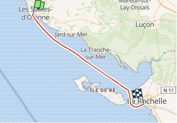
Tour Segelboot von 65 km verfügbar auf Pays de la Loire, Vendée, Les Sables-d'Olonne. Diese Tour wird von Jean Pierre Terriere vorgeschlagen.
Beschreibung
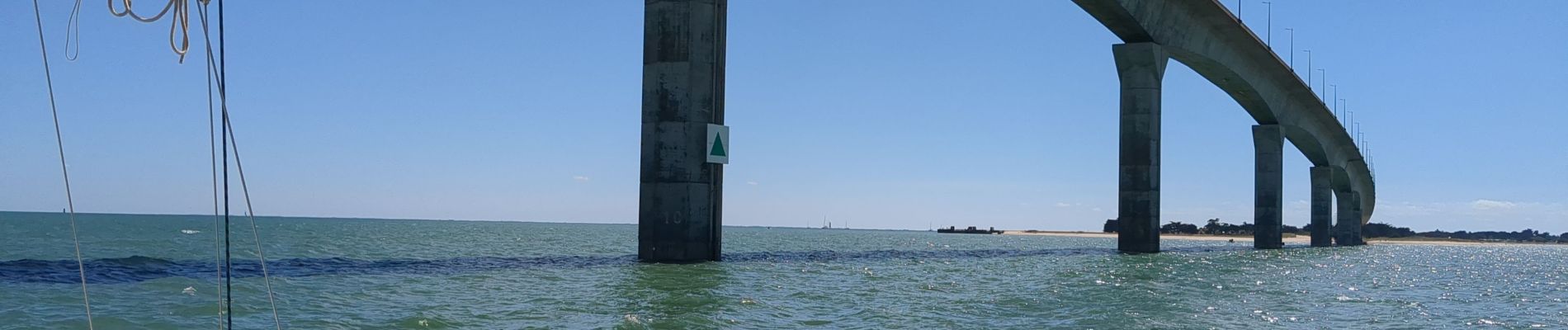
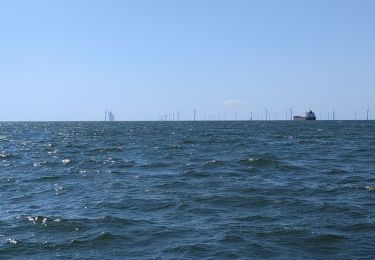
Belle étape le long de la côte Atlantique et de l'île de Ré passage sous le pont de l'île accostage au port des Minimes.
Ort
Land:
France
Region :
Pays de la Loire
Abteilung/Provinz :
Vendée
Kommune :
Les Sables-d'Olonne
Standort:
Les Sables-d'Olonne
Gehen Sie:(Dec)
Gehen Sie:(UTM)
592750 ; 5149165 (30T) N.
Kommentare
Touren in der Umgebung
![Tour Mountainbike Les Sables-d'Olonne - Pironnière vers le Veillon (le Cul d’Âne) - Photo](https://media.geolcdn.com/t/375/260/853eb98e-16c5-41f1-9677-bb9cf1715cef.jpeg&format=jpg&maxdim=2)
![Mountainbike Mountainbike](https://static1.geolcdn.com/sitytour/trail-icons/202.png)
Pironnière vers le Veillon (le Cul d’Âne)
Mountainbike
Medium
(1)
Les Sables-d'Olonne,
Pays de la Loire,
Vendée,
France
![](/images/other/stat-length.png)
22 km | 25 km-effort
1h 58min
![](https://static1.geolcdn.com/siteimages/upload/files/16400158638029165_repeat_loop_refresh_sync_direction_icon.png)
Ja
![Tour Radtourismus Les Sables-d'Olonne - Activity - Photo](https://media.geolcdn.com/t/375/260/ext.jpg?maxdim=2&url=https%3A%2F%2Fstatic1.geolcdn.com%2Fsiteimages%2Fupload%2Ffiles%2F1524743154velo.jpg)
![Radtourismus Radtourismus](https://static1.geolcdn.com/sitytour/trail-icons/204.png)
Activity
Radtourismus
Sehr leicht
(1)
Les Sables-d'Olonne,
Pays de la Loire,
Vendée,
France
![](/images/other/stat-length.png)
45 km | 49 km-effort
4h 10min
![](https://static1.geolcdn.com/siteimages/upload/files/16400158638029165_repeat_loop_refresh_sync_direction_icon.png)
Nein
![Tour Wandern Les Sables-d'Olonne - les Sables d'olonne - Photo](https://media.geolcdn.com/t/375/260/ext.jpg?maxdim=2&url=https%3A%2F%2Fstatic1.geolcdn.com%2Fsiteimages%2Fupload%2Ffiles%2F1553511878bg_sport_marche.png)
![Wandern Wandern](https://static1.geolcdn.com/sitytour/trail-icons/101.png)
les Sables d'olonne
Wandern
Sehr leicht
(1)
Les Sables-d'Olonne,
Pays de la Loire,
Vendée,
France
![](/images/other/stat-length.png)
5,8 km | 6,3 km-effort
1h 29min
![](https://static1.geolcdn.com/siteimages/upload/files/16400158638029165_repeat_loop_refresh_sync_direction_icon.png)
Ja
![Tour Mountainbike Les Sables-d'Olonne - 16-08-13 - Photo](https://media.geolcdn.com/t/375/260/ext.jpg?maxdim=2&url=https%3A%2F%2Fstatic1.geolcdn.com%2Fsiteimages%2Fupload%2Ffiles%2F1524743154velo.jpg)
![Mountainbike Mountainbike](https://static1.geolcdn.com/sitytour/trail-icons/202.png)
16-08-13
Mountainbike
Einfach
(1)
Les Sables-d'Olonne,
Pays de la Loire,
Vendée,
France
![](/images/other/stat-length.png)
38 km | 41 km-effort
2h 26min
![](https://static1.geolcdn.com/siteimages/upload/files/16400158638029165_repeat_loop_refresh_sync_direction_icon.png)
Nein
![Tour Segelboot Les Sables-d'Olonne - Turballe retour - Photo](https://media.geolcdn.com/t/375/260/6f856a52-15a7-4996-bd60-5fb43f6c48a4.jpg&format=jpg&maxdim=2)
![Segelboot Segelboot](https://static1.geolcdn.com/sitytour/trail-icons/702.png)
Turballe retour
Segelboot
Schwierig
Les Sables-d'Olonne,
Pays de la Loire,
Vendée,
France
![](/images/other/stat-length.png)
92 km | 92 km-effort
10h 16min
![](https://static1.geolcdn.com/siteimages/upload/files/16400158638029165_repeat_loop_refresh_sync_direction_icon.png)
Nein
![Tour Wandern Les Sables-d'Olonne - la Chaume Paracou - Photo](https://media.geolcdn.com/t/375/260/ext.jpg?maxdim=2&url=https%3A%2F%2Fstatic1.geolcdn.com%2Fsiteimages%2Fupload%2Ffiles%2F1553511878bg_sport_marche.png)
![Wandern Wandern](https://static1.geolcdn.com/sitytour/trail-icons/101.png)
la Chaume Paracou
Wandern
Einfach
(2)
Les Sables-d'Olonne,
Pays de la Loire,
Vendée,
France
![](/images/other/stat-length.png)
12,3 km | 13,4 km-effort
3h 6min
![](https://static1.geolcdn.com/siteimages/upload/files/16400158638029165_repeat_loop_refresh_sync_direction_icon.png)
Ja
![Tour Wandern Les Sables-d'Olonne - Orbestier Fradin les vallées - Photo](https://media.geolcdn.com/t/375/260/ext.jpg?maxdim=2&url=https%3A%2F%2Fstatic1.geolcdn.com%2Fsiteimages%2Fupload%2Ffiles%2F1553511878bg_sport_marche.png)
![Wandern Wandern](https://static1.geolcdn.com/sitytour/trail-icons/101.png)
Orbestier Fradin les vallées
Wandern
Einfach
(1)
Les Sables-d'Olonne,
Pays de la Loire,
Vendée,
France
![](/images/other/stat-length.png)
12,2 km | 13,3 km-effort
2h 48min
![](https://static1.geolcdn.com/siteimages/upload/files/16400158638029165_repeat_loop_refresh_sync_direction_icon.png)
Ja
![Tour Wandern Les Sables-d'Olonne - sentier des Gravelots - Olonne sur Mer - Photo](https://media.geolcdn.com/t/375/260/ext.jpg?maxdim=2&url=https%3A%2F%2Fservices.sitytrail.com%2FGeolivesWS%2FDownloadMedia.ashx%3FTrailID%3D139948%26Media%3D20120719121703.jpg)
![Wandern Wandern](https://static1.geolcdn.com/sitytour/trail-icons/101.png)
sentier des Gravelots - Olonne sur Mer
Wandern
Einfach
Les Sables-d'Olonne,
Pays de la Loire,
Vendée,
France
![](/images/other/stat-length.png)
3,9 km | 4,2 km-effort
1h 19min
![](https://static1.geolcdn.com/siteimages/upload/files/16400158638029165_repeat_loop_refresh_sync_direction_icon.png)
Nein
![Tour Fahrrad Les Sables-d'Olonne - La Guittière - Photo](https://media.geolcdn.com/t/375/260/ext.jpg?maxdim=2&url=https%3A%2F%2Fstatic1.geolcdn.com%2Fsiteimages%2Fupload%2Ffiles%2F1524743154velo.jpg)
![Fahrrad Fahrrad](https://static1.geolcdn.com/sitytour/trail-icons/200.png)
La Guittière
Fahrrad
Einfach
(1)
Les Sables-d'Olonne,
Pays de la Loire,
Vendée,
France
![](/images/other/stat-length.png)
61 km | 67 km-effort
2h 40min
![](https://static1.geolcdn.com/siteimages/upload/files/16400158638029165_repeat_loop_refresh_sync_direction_icon.png)
Ja